


Located a few kilometres outside Minneapolis, in the state of Minnesota, USA, the Hennepin County State Aid Highway (CSAH) 61, known locally as Flying Cloud Drive, is an important regional arterial that has historically been a key route in the regional roadway system of Hennepin County, in South-Eastern Minnesota.
The County, in coordination with Minnesota Department of Transportation (MnDOT), Carver County, and the cities of Eden Prairie and Chanhassen is reconstructing Flying Cloud Drive between Charlson Road and Highway 101.
The project involves the reconstruction of approximately 3.65 miles (5.9km) of highway. Improvements include the reconstruction of the two-lane highway segment as an urban three-lane section with curb and gutter, a continuous central left turn lane, right turn lanes and other safety improvements (lighting, skew corrections, etc.) at key intersections. The new roadway will replace the existing pavement and improve the driving surface and safety along the corridor.
The roadway will also be raised in several locations above the 100-year floodplain to help minimise the potential for transportation disruptions such as road closures during Minnesota River flood events.
The project will also add a multi-use trail along the north side of the road that will connect to existing and planned trails at both the east and west ends of the project area, filling the gap in the trail network from Shakopee to Eden Prairie.
Portions of the landscape adjacent to the highway corridor remain undeveloped and consist of forested areas, wetlands and floodplain areas that are home to a variety of wildlife species. That is why several design modifications (minor alignment shifts, retaining walls, steep side slopes, use of guardrail, etc.) have been incorporated into the design of the proposed roadway improvements to avoid and minimise impacts to wildlife habitat, rare plant communities, and sensitive ecological resources.
The project also involves several drainage and water management features to collect and treat stormwater runoff from the new roadway and trail surfaces, improving water quality in nearby wetlands that act as filters for the water that will eventually flow into the nearby Minnesota River.
Project construction requires major grading and excavation, as well as permanent and temporary right-of-way easements and full closures to through traffic in order to construct and maintain the roadway facility.
The project is being carried out in two stages. The first stage was completed between spring and autumn of 2018 and included: reconstruction of the Riley Creek Bridge; reconstruction of Flying Cloud Drive between Spring Road and Charlson Road; construction of retaining walls; and realignment of Spring Road and paving the new road.
The second stage started in autumn of 2018, will take between 12 and 14 months to complete and involves working on Flying Cloud Drive from Spring Road and Highway 101.
Soil conditions
Soils in the Minnesota River bottomlands in the project area belong to the Alluvial Land-Chaska-Oshawa Association. These are characteristically poorly drained medium textured to moderately fine textured soils. Native soils along the project alignment include marsh, alluvial land, alluvial land frequently flooded, and Terril loam. Soils in the existing roadway embankment consist of fill soils, such as silty sand, silty loam, loamy sand, sandy loam and sandy clay loam. The marsh soils consist of peat and organic clays of low and high plasticity.
Based on field investigation, including soil borings, the depth to groundwater along the study corridor varies and at its shallowest depth is only 1-2ft (0.3 - 0.6m) below the ground surface.
Slope stabilisation
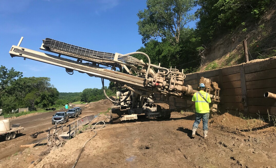
As part of the project, 1,200 grouted tieback anchors with double corrosion protection are being installed along an approximately 2.5-mile (4km) stretch of roadway. The anchors are used to provide support to seven retaining walls with a variable length from about 500 to over 1,000ft (152 - 305m), pushing back the hillside for the road-widening project. The anchor installation is being carried out by Atlas Foundation, a deep foundation speciality contractor serving the upper Midwest region since 1968.
"The primary difficulty on the project was identifying and adapting to varying soil conditions," explains Mike Moeller, owner of Atlas Foundation. "Due to the length of the walls and the highly variable soil conditions, we would encounter multiple changes in the soil profile at each wall. The mix of sand, silt and clay included extremes that varied from dry ‘beach sand' to over-saturated ‘muck'. The construction process for grouted tieback anchors is generally: design, fabricate, install, test. This construction process makes it difficult to adapt to variable soil conditions."
Atlas Foundation is also using a Comacchio MC 15 P to stabilise the slopes on its Minnesota highway project
Anchors are drilled through trumpet pipes after the soldier piles for the retaining walls have been installed. The grouted anchors have design loads of up to 240 kips (1,068kN), requiring 50ft (15.2m) bond length. "The grout columns have 7in diameter," Moeller points out. "As we had to drill our anchors through the retaining wall, the diameter was limited due to the prefabricated trumpet pipes in the soldier piles. The 50ft bond lengths are at the limit (some would say beyond the limit) of an effective bond length for a grouted tieback anchor, but that was also determined by the specific soil conditions."
The casing installation is performed using a powerful lower head
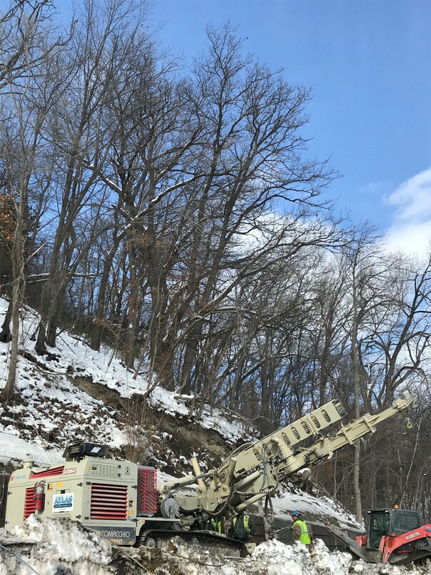
The drilling is primarily carried out below the groundwater table. Temporary casings are therefore being used and the drilling is performed using DTH hammer with air flushing. "We are utilising a Comacchio MC 28 HD with a double-head system to install the temporary casing. The casing installation is performed using a powerful lower head providing up to 4,800daNm torque. Thanks to the long stroke mast design of the rig we are reaching productivity rates of up to 700ft (213m) of drilling and grouting tiebacks per day over up to 16 tieback locations," explains Moeller. "However, in situations with silty soils, this approach would create a suction effect inside the casing, below the water table, when we turned off the air. The negative hydraulic head at the bottom of the casing would make it fill up with water and silt sediment. This soil condition requires a change to a slurry/water drilling approach to equalise the head pressure during drilling and prior to removing the hammer and the drill steel from the temporary casing."
Along with the MC 28 HD, two Comacchio MC 15 P are being utilised on the project, both of them in double-head configuration. To allow a better vision of the borehole and guarantee a safer and easier operation, all the rigs involved in the project are entirely radio controlled.
Every anchor on the project is being load-tested. "We performed extended creep tests on two per cent, performance tests on five per cent and proof tests on all the remaining anchors," says Moeller. "The project is currently ongoing, but wall one is complete with the roadway open to the public, three walls have the poured-concrete finished wall in place, two walls are about 50 per cent complete on installed and tested anchors with one wall remaining." The project is scheduled to be complete in early 2020.