geological visualisation
MINING
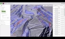
GeoSpatial Manager introduced by Maptek
A new visualisation tool for miners and civil engineers was introduced by Maptek during Geoweek 2024
16 February 2024
GEOTECHNICAL & GEO-ENVIRONMENTAL
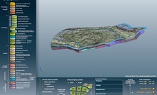
BGS releases free-to-access 3D underground regional models
Interactive 3D underground visualisations of the UK released by the British Geological Survey
08 February 2019
PARTNER CONTENT
A Sneak Peek at the Future of Drilling Data
Drilling is the first step in an optimised mine value chain, so it is crucial to
PARTNER CONTENT
Gain Ground on the Competition
Rigs, tooling designed for direct push propel profits, production across industries
PARTNER CONTENT
Simplify your geotechnical Jobs
Multi-application drill rigs and enhanced tools boost productivity and profits.
THE ASPERMONT BRAND PORTFOLIO


Copyright © 2000-2024 Aspermont Media Ltd. All rights reserved. Aspermont Media is a company registered in England and Wales. Company No. 08096447. VAT No. 136738101. Aspermont Media, WeWork, 1 Poultry, London, England, EC2R 8EJ.