


A groundbreaking project to drill the Khumbu Glacier has found the world's highest glacier - 6660m above sea level in northeastern Nepal between Mount Everest and the Lhotse-Nuptse ridge - is close to melting point, with evidence "of significant melt and refreezing events".
Eminent glaciologist Professor Bryn Hubbard of the Centre for Glaciology at Aberystwyth University led a team of researchers to Nepal in 2025 to collect high-resolution borehole images and core samples from the upper reaches of the Khumbu Glacier, as part of a project to extract valuable information about the effects of global warming.
The team used a Robertson Geo High Resolution Optical Televiewer (Hi-OPTV) with a lightweight Mini Winch system and Full Waveform Triple Sonic probes to look into "the water towers of the world".
The glaciers of Nepal are at high altitudes up to 8400m, with many covered in debris at lower altitudes making them difficult to study. Previous visits, by Professor Hubbard et al in 2017 and 2018, as part of the Everdrill project, drilled 27 boreholes into the lower glacier, of which four were logged using the Hi-OPTV unit. The millimetre scale televiewer data revealed englacial debris content and the glacier's internal structures, interpreted as several generations of stratification and foliation.
The behaviour of these high-altitude debris covered glaciers was heavily influenced by the summer monsoon and they exhibited a different pattern of mass loss from that of low elevation glaciers, the researchers found.
Nepal contains around 4000 glaciers covering some 4000km2. Between 1977 and 2010 around 24% of area and 29% of volume was lost. The ice loss is accelerating.
The effects of global warming are known to be greater above 2000m with an average temperature increase of 3°C measured between 1975 and 2015. The warming effect is compounded by changing weather and monsoon patterns resulting in reduced snowfall and increased rainfall at high elevations.
The consequences of glacier mass loss are profound and wide ranging. Over 10% of the world's population rely on Himalayan glaciers for fresh water, glacial lake growth in the region has potential hazard implications, agriculture and hydropower industries are under threat, and water security on all scales is compromised.
Glaciologists are concerned that the system is now near "peak water", which is the tipping point in a glacier's contribution to streamflow, where annual meltwater runoff reaches its maximum volume and begins to decline.
Melting point
Based on the work of Everdrill, a hypothesis was proposed for testing under the "Losing their Cool" project, which is funded by the NERC "Pushing the Frontiers" scheme. Results show that over half of the ablation (the loss of mass from a glacier) area of the Khumbu Glacier comprises ice that is at melting point. Yet, even summer temperatures in the high Western Cwm reach a maximum daily mean of about -9°C, and such rapid warming cannot be accounted for by atmospherically driven thermal conduction, they claim. An additional or supplementary process must be warming the ice.
The methods used by the Losing their Cool project team included coring to characterise structures and firn/ice density; optical televiewing to investigate structure within the firn at a high resolution, and to provide a density estimate; and the installation of thermistor and automatic weather station to evaluate temperature profiles, including radiation levels.
The planning and logistics for the project began around six months before the visit, organised by Himalayan Research Expeditions, which managed the main expedition logistics and permits. The ground team was supported by local guides and Sherpa, notably Dhankaji Tamang who was an invaluable asset to the team, drawing upon his vast climbing experience in the Himalayas.
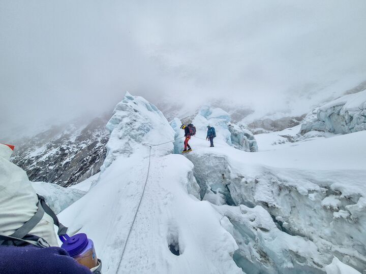
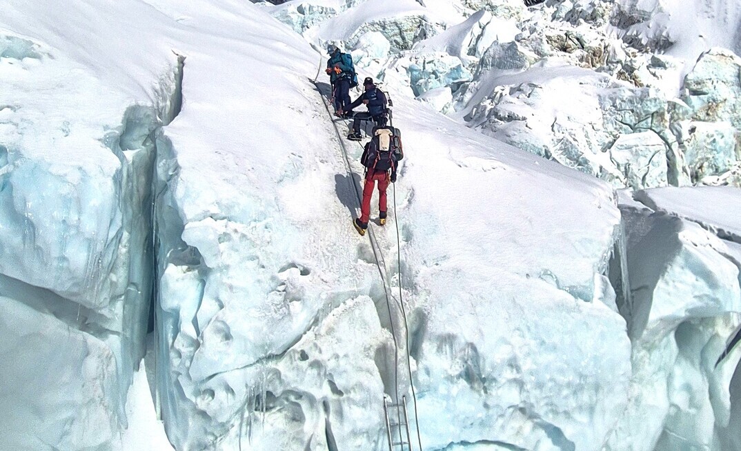
A drilling team of three climbed the Khumbu Icefall, with the heaviest equipment transported by helicopter directly from Base Camp.
For this project, to the upper reaches of the glacier, weight was limited by the helicopters used to deliver the equipment, having approximately one tenth of their payload capacity at sea level. The equipment used for coring was a lightweight system based on a Kovacs Mark III Ice Coring System driven by a Makita Earth Auger using battery power, producing ice cores of 72.5mm diameter up to 1m long.
For the thermistor installations, a Heucke steam drill was used which creates a much smaller diameter hole for the thermistors to have better contact with the surrounding firn.
Previous visits to the lower reaches of the Khumbu glacier used a pressurised hot water drilling method to create boreholes for televiewer logging and thermistor installation.
Meltwater or flowing water was collected in a tank and fed under gravity to a high-pressure pump feeding a diesel heater. Water, heated to 70°C, then passed through a spooled hose terminated with a high-pressure nozzle on the end of a brass stem, which was lowered slowly into the borehole. The water melted the ice in the borehole just ahead of the nozzle, producing vertical boreholes around 200mm diameter at drill rates above 1m/min.
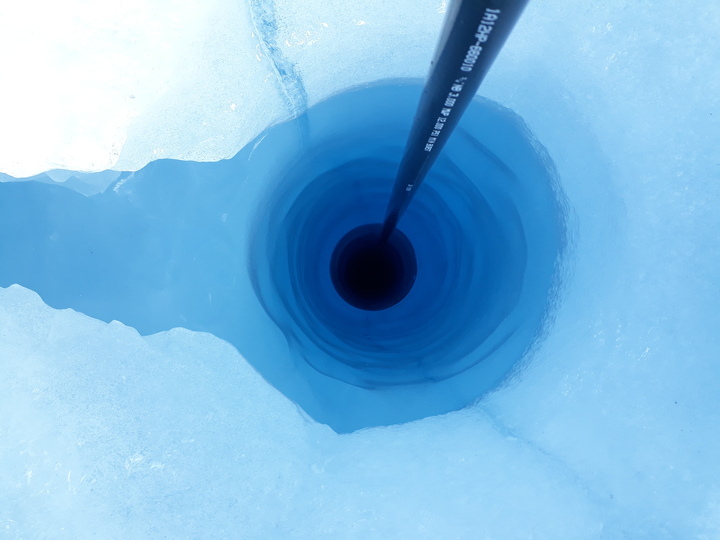
The core drilling programme was unfortunately limited due to having a brief time window for working in the Cwm, with one borehole cored to a depth of 6m, for televiewer logging, yielding 72.5mm core samples. Optical televiewer logging was carried out on 6m englacial borehole providing detailed critical information.
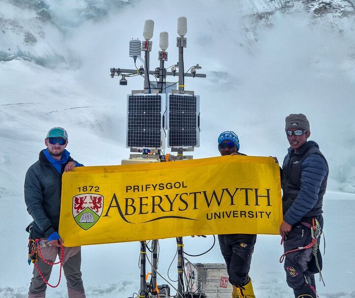
Thirty thermistors were installed in the firn layer up to 12m deep and the automatic weather station was installed at the drill site (6660 m) to collect meteorological and thermistor data for satellite transmission.
Team challenged
Almost every aspect of the project challenged the team. Altitude sickness, brain fog, low blood oxygen levels and a drill site typically lower than -9°C during the day falling to -25°C or lower at night, and with wind chill the temperature could feel 15°C colder.
Despite the dangers, some novel data was collected to test the project's hypothesis. Preliminary results verify "very warm" firn temperatures of about -2°C in the upper 3m of the firn layer and -2°C to -4°C in the upper 6m of the firn layer. The presence of refrozen ice in the near-surface firn was also recorded, with changes in thermal conductivity. There was also evidence of significant melt and refreezing events.
The data collected will be used to improve glacial models pertaining to mass loss and the dynamic behaviour of high-altitude debris covered glaciers.
A further expedition to the Western Cwm in spring 2026 is in the planning.
The project team comprised:
- Professor Bryn Hubbard, Principal Investigator, Aberystwyth University
- *Dr Matthew Peacey, (Postdoc: instrumentation), Aberystwyth University
- *Professor Duncan Quincey, Principal Investigator, University of Leeds
- Dr Sunil Oulkar, (Postdoc: modelling) , University of Leeds
- Professor Ann Rowan (Co-Investigator), University of Bergen
- *Dr Tom Matthews (Co-Investigator), Kings College London
- Professor Ward van Pelt (Co-Investigator), Uppsala University
- (* indicates the members of the drilling team)


