geological visualisation
MINING
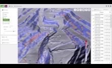
GeoSpatial Manager introduced by Maptek
A new visualisation tool for miners and civil engineers was introduced by Maptek during Geoweek 2024
16 February 2024
GEOTECHNICAL & GEO-ENVIRONMENTAL
BGS releases free-to-access 3D underground regional models
Interactive 3D underground visualisations of the UK released by the British Geological Survey
08 February 2019
PARTNER CONTENT
From variability to control, Molycop's OreVia platform
How Molycop's OreVia works in practice and the operational value it is delivering
PARTNER CONTENT
Full flowsheet, full lifecycle: FLS sharpens its performance focus
Qasim Abrahams explains how FLS helps miners improve performance across full processing
THE ASPERMONT BRAND PORTFOLIO


Copyright © 2026 Aspermont Media Ltd. All rights reserved, including those for text and data mining, AI training, and similar technologies. Aspermont Media is a company registered in England and Wales. Company No. 08096447. VAT No. 136738101. Aspermont Media, Moor Place, 1 Fore Street Avenue, London, England, EC2Y 9DT.