National Underground Asset Register

GEOTECHNICAL
UK Geotechnical Data Bill passes for second read
Proposal to mandate geotechnical data be included in the National Underground Asset Register
19 March 2026

SITE INVESTIGATION
Ground investigation in the modern age
Exploring the latest advances in ground investigation - AI, machine learning and more
04 July 2025
UTILITIES
UK's National Underground Asset Register to be operated by Ordnance Survey
OS to operate the NUAR, with the service transitioning to public beta in spring 2025
09 October 2024
INFRASTRUCTURE
New underground digital map launched in the UK
Digital map of underground utilities in the UK launched to improve safety and work efficiency
05 April 2023
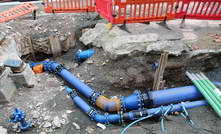
GROUNDWATER
Safety map will pinpoint UK's million miles of pipes and cables
UK national underground utility mapping introduced to increase worker safety
05 July 2021
PARTNER CONTENT
A decade in the mixing market
Challenges in developing tailored technologies – the EURODRILL RHP15 story
PARTNER CONTENT
From variability to control, Molycop's OreVia platform
How Molycop's OreVia works in practice and the operational value it is delivering
PARTNER CONTENT
Full flowsheet, full lifecycle: FLS sharpens its performance focus
Qasim Abrahams explains how FLS helps miners improve performance across full processing
THE ASPERMONT BRAND PORTFOLIO


Copyright © 2026 Aspermont Media Ltd. All rights reserved, including those for text and data mining, AI training, and similar technologies. Aspermont Media is a company registered in England and Wales. Company No. 08096447. VAT No. 136738101. Aspermont Media, Moor Place, 1 Fore Street Avenue, London, England, EC2Y 9DT.